IN-DEPTH READING
Reconstructing the landscape around Golgotha
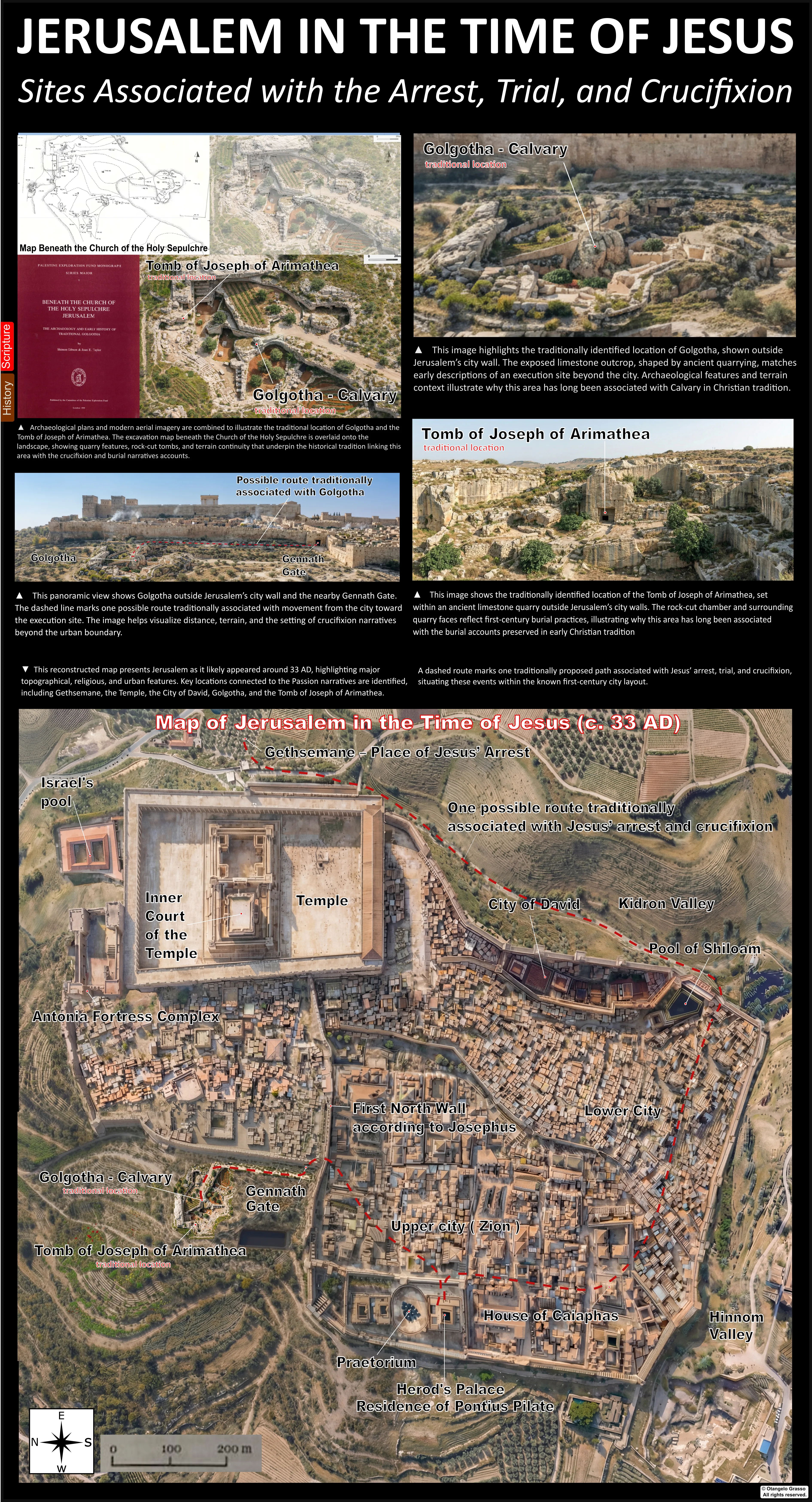
The Church of the Holy Sepulchre stands over a real ancient quarry, with surviving bedrock, quarry cuts, burial features and later construction beneath its floors. That physical setting helps explain why the site has long been associated with Jesus’ crucifixion and burial. It does not, by itself, identify a particular rock spur as Golgotha, date every tomb to the first century, or prove that the Gospel events occurred at one exact point. The evidence is strongest for the quarry landscape; the precise event locations remain debated.
1. What the Gospel accounts say about place
The four canonical accounts call the execution site Golgotha, translated as “Place of the Skull.” They place the execution outside the city or near a road; John also says that a garden and a new tomb were near the place where Jesus was crucified. Those are useful geographical clues, but none of the accounts supplies a street plan, measured distance, gate coordinates or a detailed description of the ground surface.1
Hebrews 13:12 compares Jesus’ suffering “outside the gate” with the disposal of sacrificial remains outside the camp. That passage is a theological interpretation of the crucifixion. It should not be treated as an independent survey of Jerusalem’s walls. Likewise, Roman use of public executions as a warning may help explain why roads and visible approaches matter, but it cannot tell us which road or which quarry was used in this particular case.2
It is useful to keep three claims separate: the Gospel narrative gives a broad setting; archaeology identifies a quarry and later funerary and agricultural uses at the traditional site; identifying a particular rock feature as the place of execution is a further historical inference.
2. The traditional site and the archaeology beneath the church
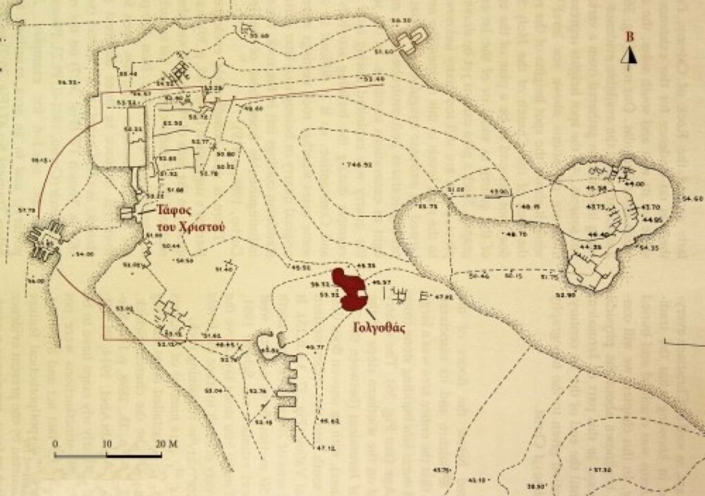
The Holy Sepulchre is not simply a medieval church placed over an arbitrary point. Excavations and earlier observations show that the complex covers an area of uneven bedrock that had been quarried, later altered and reused. The archaeological record is fragmentary because investigations took place in separate areas during restorations, and much of the ground is now inaccessible. Shimon Gibson and Joan Taylor’s 1994 synthesis brings together earlier excavation records, plans and observations; it is a key source for understanding both the quarry and the limits of what can be reconstructed from it.3
Excavations by Virgilio Corbo and others exposed quarry surfaces, cuts and rock-cut features beneath parts of the church. Work in the Chapel of St. Vartan by Magen Broshi and Gabriel Barkay documented Iron Age material and quarry-related remains within a distinct excavation area. These findings support a long history of stone extraction in the vicinity. They do not establish that every exposed face belongs to one quarrying episode or that every feature visible today dates to the time of Jesus.34
The 2022 excavation campaign inside the basilica, reported by the Israel Antiquities Authority in 2024, exposed additional quarried bedrock and remains of funerary structures. The report notes that some bedrock was left in place during extraction and that quarry marks indicate more than one technique and phase of use. The authors describe the later exploitation of parts of the quarried area as cultivation plots, formed by filling small areas and enclosing them with dry-stone walls.5
A 2025 preliminary report from the Sapienza excavation team provides a wider synthesis of the completed excavation areas. It describes multiple extraction phases and later agricultural and funerary reuse. These are significant additions to the archaeological picture, while remaining preliminary publication of a complex, multi-period site.6
3. City walls, gates and the meaning of “outside”
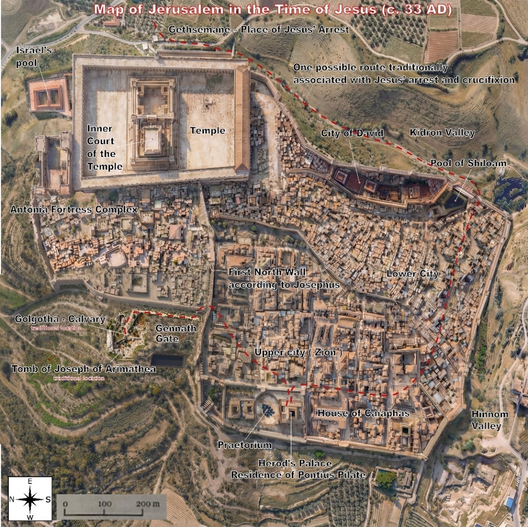
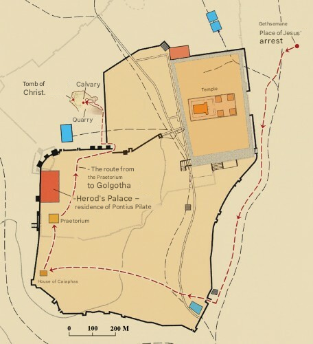
The traditional Holy Sepulchre site is generally understood to have been outside Jerusalem’s inhabited area and the relevant first-century wall line when the Gospel events are set. The route of the Second Wall, however, has been reconstructed from dispersed remains and historical arguments; it is not preserved as one continuous wall that can be followed beneath the modern city. The exact positions of the wall, Gennath Gate and adjacent roads are therefore model-dependent. A map can clarify a proposal, but a dashed line on a modern reconstruction is not an excavated street.
Joan Taylor’s reassessment distinguishes the area-name Golgotha from the exact location of the cross and the tomb. She argues that execution could have taken place nearer Gennath Gate and the roads, while the burial could have been farther north, at the traditional tomb. This proposal accepts the Holy Sepulchre tomb as a possibility while placing the execution point elsewhere within the broader quarry landscape. It demonstrates why “the Holy Sepulchre site” need not mean that crucifixion and burial occurred at one precise spot.7
4. What the quarry can—and cannot—tell us
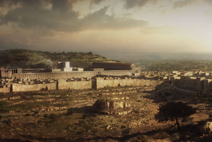
The visible and excavated bedrock makes the quarry interpretation persuasive. The ground is irregular, with extraction faces, benches and areas where stone was partly detached or left behind. Quarrying altered a natural slope into a stepped working landscape. Later construction cut through, buried or reused parts of that terrain, so the present church and its floor levels cannot simply be projected backward as a complete first-century surface.
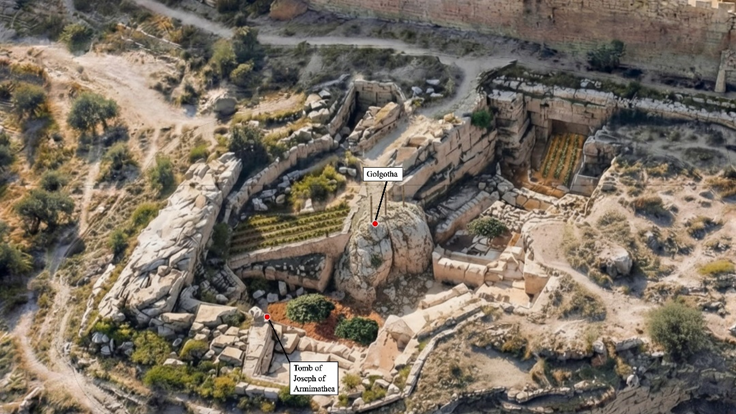
The author’s three-dimensional synthesis quotes elevation benchmarks of 758.3 metres for a proposed Golgotha summit, 753.2 metres for a tomb-level bench and 743.7 metres for a lower quarry floor. Taken at face value, these produce vertical differences of 5.1 metres and 9.5 metres. They are useful as a model of the reported vertical relationships, but the exact values should be checked against the original survey records, their datums and the separate excavation campaigns before being treated as a single, independently verified site-wide measurement.310
| Model level | Reported elevation | What it represents |
|---|---|---|
| Upper spur | 758.3 m | Proposed Golgotha outcrop in the author’s reconstruction |
| Intermediate bench | 753.2 m | Bench associated in the model with the traditional tomb area |
| Lower quarry surface | 743.7 m | Lower level in the reconstructed quarry profile |
The numbers describe the model’s proposed vertical arrangement, not the height of a surviving isolated hill above a known ancient road. They do not establish the exact location of a cross, the number of crosses, the height of the execution platform or a measured sightline from every point in the city. Those are additional questions requiring secure coordinates and a transparent reconstruction of the changing terrain.
5. Cultivation evidence and the Gospel garden
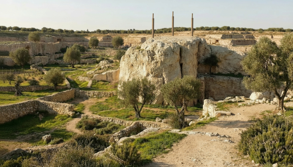
John’s description of a garden near the tomb is sometimes presented as if archaeology had now identified a particular first-century garden plot. The published evidence is more limited. The 2024 Israel Antiquities Authority report describes small cultivation plots in the latest phase of quarry exploitation. It reports remains of cereals, grapes, figs and grasses; grapevine wood in one locus cautiously suggests grape cultivation on site, while pollen analysis indicates the possibility of olive cultivation.5
The 2025 preliminary synthesis likewise describes agricultural and funerary reuse of the quarry. Taken together, these findings establish that cultivation formed part of the site’s history. The public reports do not identify a named plot as the Gospel garden, connect a particular seed or pollen sample directly with Jesus’ burial, or show that every botanical result belongs to the same short period. Archaeobotanical evidence can reconstruct land use; it cannot, by itself, identify the owner or the event narrated in a text.56
Earlier discussions of the site relied partly on Corbo’s interpretation of the quarry’s later use as a garden and on the Gospel account. The newer excavations add material evidence for cultivation, but they also encourage a more precise question: which deposits, plants and walls belong to which phase? That stratigraphic work matters more than a visually convincing garden scene.
6. Tombs, burial customs and the traditional tomb
The Gospels describe Joseph of Arimathea’s tomb as new and close to the execution site. Archaeology can show that rock-cut tombs and funerary structures existed in and around the quarried area; it cannot identify one as Joseph’s without a securely attributable inscription or another direct link. The 2024 excavation report notes damaged funerary structures resting on quarried bedrock in the rotunda area, but does not identify those remains as the Gospel tomb or assign them to Jesus’ burial.15
The traditional tomb is encased within the church’s later architecture. Constantine’s building program, described by Eusebius, monumentalized a place Christians in the fourth century identified with Jesus’ tomb. The Bordeaux pilgrim’s itinerary, written in the fourth century, also records Golgotha and the associated pilgrimage landscape. These sources are important evidence for late-antique tradition and the development of the shrine. They are not contemporary records of the burial several centuries earlier.89
The Garden Tomb north of the Old City is a separate proposal, popularized in the nineteenth century. Gabriel Barkay’s typological study argues that the cave’s original form belongs to Iron Age II, centuries earlier than the Gospel setting, and that later alterations complicate its use as a first-century tomb. This weighs against identifying that particular cave as a newly cut tomb from the time of Jesus. It does not settle the location of the crucifixion, and it does not make a visual resemblance or devotional appeal archaeological evidence.11
Burial architecture must therefore be evaluated at the level of each feature and phase. A chamber may be cut in one period, adapted in another, and reused again later. Terms such as kokh, arcosolium and rolling-stone closure describe forms found in the region, but applying one label does not automatically date a specific cave or prove that it was newly prepared for a particular burial.
7. Reading the reconstructions as models
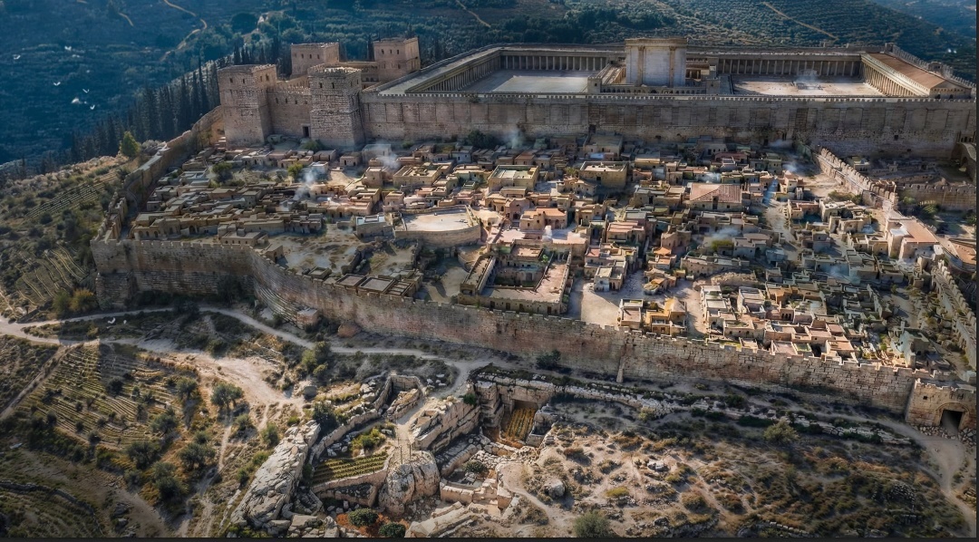
A three-dimensional model is useful because quarry archaeology is inherently vertical. A plan can show where cuts and tombs lie horizontally, while a section or digital landscape can make terraces, scarps and level changes easier to compare. The author’s model combines published plans, reported elevations, aerial views and proposed identifications. Its value is explanatory: it makes one reconstruction visible enough to inspect and question.
Its limits are equally important. The models do not all derive from a single modern survey; some combine plans from different excavations with aerial imagery and artistic reconstruction. A reader should ask which source controls each coordinate, what scale and elevation datum were used, which features are directly observed, and which are filled in to complete the scene. Until those inputs are published together in reproducible form, the finished 3D image should be treated as a hypothesis made visible, not as a substitute for the excavation record.
8. What the evidence supports
The evidence can be summarized in levels of confidence:
- Well supported: the Holy Sepulchre stands over an ancient quarry landscape; quarrying, funerary use and cultivation are documented in different areas and phases.
- Plausible but debated: the traditional site preserves the general location of the crucifixion and burial, and the quarry’s topography provides a credible setting for the Gospel descriptions.
- Not established: the exact rock spur used for the cross, a precise route or viewing angle, the identity of a particular tomb as Joseph’s, or the claim that the current 3D images reproduce the site exactly as it appeared in AD 30.
The strongest case for the traditional site is cumulative: it lies in the relevant extra-mural landscape, it contains a quarry and funerary features, and Christian identification is documented by the fourth century. The main caution is that each strand has a different date and evidentiary reach. Late-antique tradition demonstrates an early and influential identification; excavation demonstrates the landscape’s physical history; neither alone proves the exact first-century event point.
The Church of the Holy Sepulchre remains a serious and historically grounded candidate for the place remembered as Golgotha and the tomb. A careful reconstruction can show why. It should also leave room for the distinction between a broadly plausible sacred landscape and a precisely located execution scene. The stones are real; the detailed story drawn across them remains an argument to test.
References
- The four canonical Gospels: Matthew 27; Mark 15; Luke 23; John 19. Read the Passion and burial accounts (NRSVUE).
- Hebrews 13:11–13; Leviticus 24:14; Numbers 15:35–36. Read the passages.
- Gibson, Shimon, and Joan E. Taylor. Beneath the Church of the Holy Sepulchre, Jerusalem: The Archaeology and Early History of Traditional Golgotha. Palestine Exploration Fund, 1994. Read the archaeological monograph (PDF).
- Broshi, Magen, and Gabriel Barkay. “Excavations in the Chapel of St. Vartan in the Holy Sepulchre.” Israel Exploration Journal 35, nos. 2–3 (1985): 108–128. Publication record.
- Stasolla, Francesca Romana. “Jerusalem, Church of the Holy Sepulchre.” Hadashot Arkheologiyot 136 (2024), preliminary report on the 2022 excavations. Read the Israel Antiquities Authority report.
- Stasolla, Francesca Romana, et al. “Archaeological Excavations in the Holy Sepulchre, Jerusalem: 2025 Preliminary Report.” Liber Annuus 75 (2025): 619–716. Read the publication record and abstract.
- Taylor, Joan E. “Golgotha: A Reconsideration of the Evidence for the Sites of Jesus’ Crucifixion and Burial.” New Testament Studies 44, no. 2 (1998): 180–203. Read the article record.
- Eusebius of Caesarea, Life of Constantine, Book III, especially chapters 25–40. Read the primary text.
- The Bordeaux Pilgrim, Itinerarium Burdigalense (333 CE), Jerusalem section. Read the itinerary and translation.
- Grasso, Otangelo. “Golgotha and the Jerusalem Quarry Complex: A Comprehensive Archaeological Reconstruction of the First-Century Crucifixion Landscape.” Author’s research paper, January 2026, written with AI assistance. Its 3D images and measurements present the author’s synthesis and should be assessed against the underlying excavation publications. Download the paper (PDF).
- Barkay, Gabriel. “The Garden Tomb: Was Jesus Buried Here?” Biblical Archaeology Review 12, no. 2 (1986): 40–57. Read the article.
The author’s quarry reconstruction and its bibliography are available in the linked research paper above. For excavation results and alternative interpretations, consult the archaeological reports and studies cited in the references.